For each exercise,
an objective is stated
then the exercise is described. Naturally, the exercises use
maps.
This page contains exercise descriptions and sample map segments for
some
of the exercises.
Where
one or more years are listed, those are the years when WPOC used these
exercises in training.
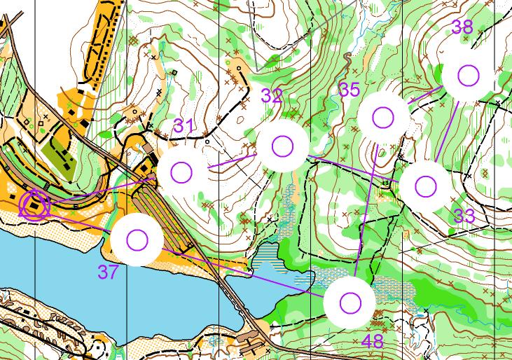
Attack
Point Identification (Donut-O)
(2013, 2016, 2018, 2023)
Objective: To get
better at picking
attack points
Maps have been
prepared with the area around a control blocked out. Find an
attack
point for each control and run to it. Then, using careful
compass
reading, navigate to the control. You can go to the controls
in any
order; or a sequence may be specified.
Here is an
example: Donut-O
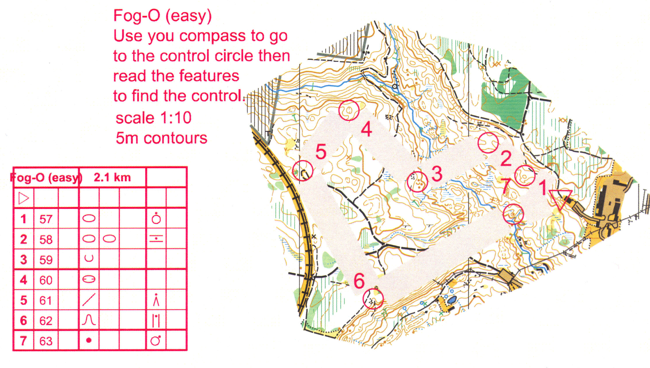
Compass Use
(Fog-O)
(2013, 2017, 2019)
Objective: To make
effective use
of the compass
Maps have been
prepared that block out the map on either side of the connecting line
between
controls. Use only the compass to navigate to the
controls.
This may be done in two versions, one in which narrow corridors between
controls are blocked out and one in which wide corridors are blocked
out.
Here is a sample in which narrow corridors are blocked: Fog
Orienteering
Route Choice
Objective: To pick
the best route
in the least amount of time
Leg Splitting. Mark a map with several long legs. Identify attack points along the way that will make the long leg into several short legs. This may be done as a written exercise or done in the woods.
Keep the Pen Moving
(written exercise).
Using any map from a previous competition, draw the plan of your route
without
letting your pen stop. Ask another orienteer to
analyze your
routes.
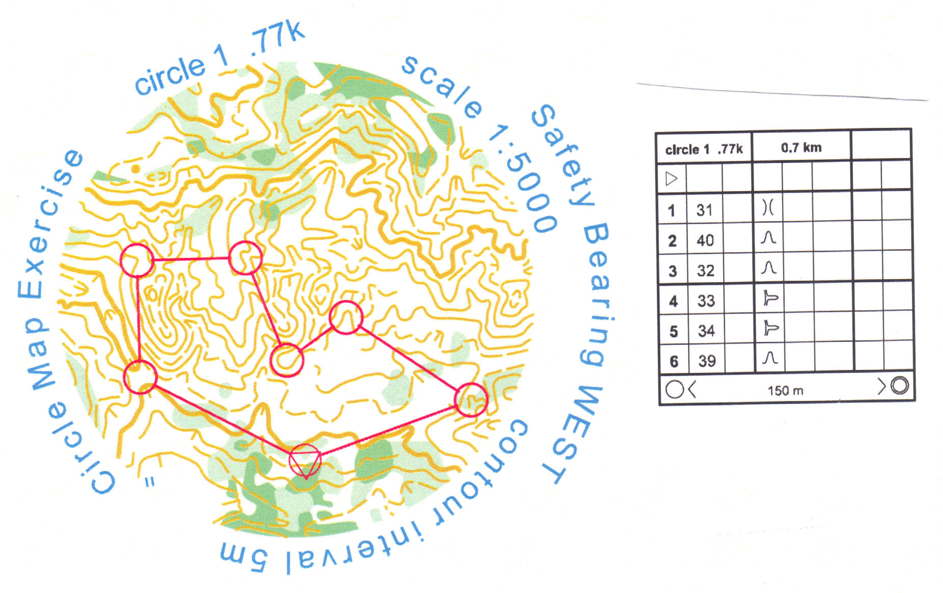
Circular Map
(2014)
Objective: To
practice reading contours
Make multiple
version of a course that
are all comparable in terms of length and difficulty. Draw
these
courses on small circular maps that have had all elements other than
contours
(and perhaps vegetation) removed. The maps are NOT oriented
on the
page and there are no north indicators. Using only the
contours,
find your way around the course. Keep the map oriented using
the
land forms. You may trade maps with someone else who has a
different
version and try a second time. This sample has vegetation in
addition
to contours: Circular
Map
Corridor O
(2012,
2016)
Objective: To
navigate using only
the compass and contours
Maps consist of a
serpentine strip, showing
a twisting, turning loop which shows the land about 40 meters wide
around
the loop. The maps show only contours (and perhaps
vegetation); all
other elements,including north lines, have been removed.
Traverse
and punch at any controls that you find as you go around the loop;
control
locations are not marked on the map. You may traverse the
loop in
either direction. In this sample, two small pieces of road
are the
only black features on the map: Corridor
Orienteering
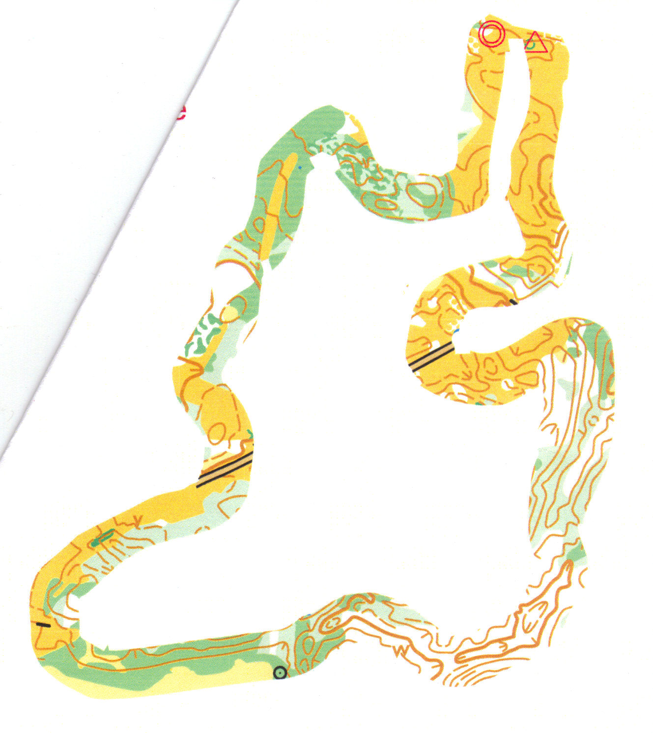
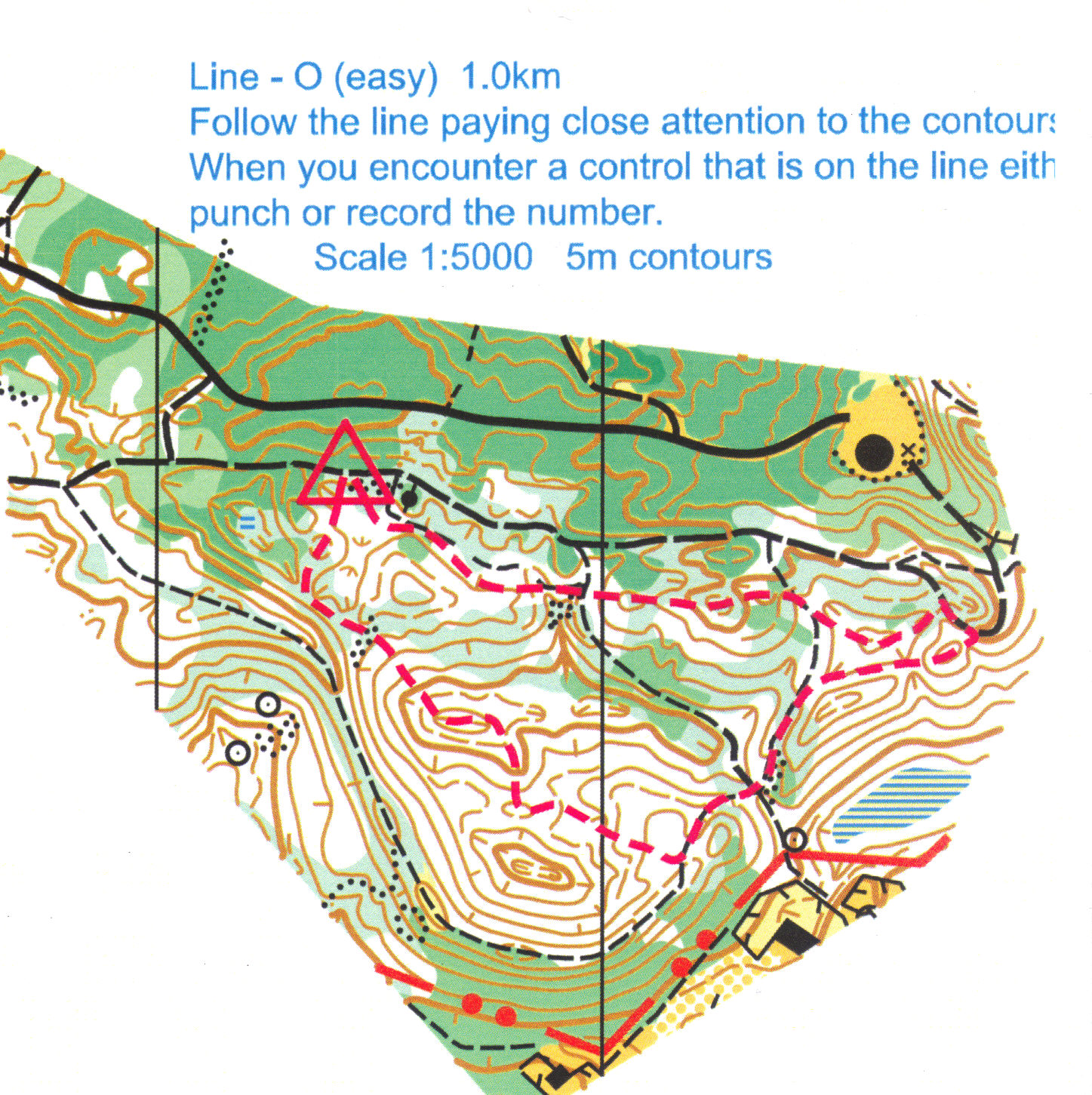
Line O
(2012,
2015, 2018, 2022, 2024)
Objective: To stay
in contact with
the map
Maps have been
prepared that show a twisting,
turning line from the marked start to the marked
finish. You
are to follow the line, punching at controls that you find along
the
line. You will be given a list of the control numbers for controls that
are on the line; however, there will be no description of the control locations.
This exercise may be done in two versions:
one in which
a normal map is used, the other in which all trails have been
removed.
For an extra challenge, take a pencil with you and mark the locations
of
all controls that you find on the map. This sample uses a
normal
map: Line
Orienteering
Map
Simplification
(2012)
Objective: To
practice identifying
the major features needed to navigate to a control
On a blank sheet of
paper, draw a simplified
copy of the provided map with a course already on it. Put on
your
map only the major features that are needed to get to the control and
the
control itself. Do this for each leg of the course.
Then, use
the hand-drawn map to navigate around the course. Take the
copy of
the provided map with you ... just in case.
Memory Duo
Objective: To pick
out the most
important features to memorize a leg of a course
Work in pairs, using
one map. Partner
A memorizes the first leg and hands the map to partner B.
Then, A
leads B to the first control without consulting the map.
While following
A to the first control, B memorizes the second leg. At the
first
control, B hands the map to A; B then leads the way to #2 while A
follows
and memorizes the next leg. Continue switching roles at each
control.
The key to the memorization is picking out the major features that are
needed to navigate to a control.
Mass Start
Objective: To do
mass starts and
run with a group, with forking
There is an A course
map and a B course
map and the courses use forking. Each person at the mass
start has
either an A or B course and is to go through the course s/he
has,
After completing one of the courses, each runner should return to the
start
for the next mass start and run the other course. The two
mass starts
are 30 minutes apart; there may be additional mass starts if groups
show up later.
Super
String O
Objective: To
practice punching
faster
A string-O course is
set up, looking just
like one for 3- and 4-year-olds, except with lots of regular controls.
Each person starts on the course in a normal interval start and tries
to
finish as fast as possible, punching at every control. The
idea is
to try to make your punching action at each control as smooth as
possible.
Pathless-O (2012,
2016, 2017, 2018, 2019, 2022, 2023, 2024)
Objective:
To practice
using contours and vegetation features in terrain association; also to
practice using the compass and making distance measurements.
Find the
controls in a normal cross-country orienteering course using a map in
which
most of the features that would be drawn in black have been
removed. That is, no roads, no trails, no rides and optionally no power lines, no parking areas.
If you are thinking of doing more than one exercise, do this one first
- the other exercises will show the trails, roads, etc. which would
partly
defeat the purpose of this exercise. Here is an example map:
Pathless
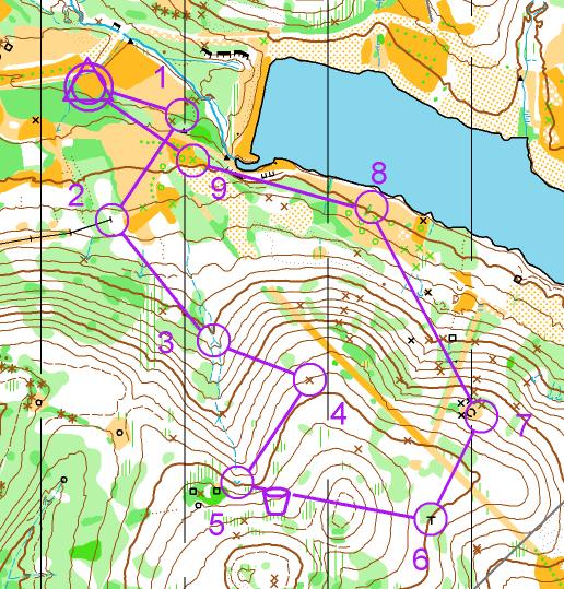
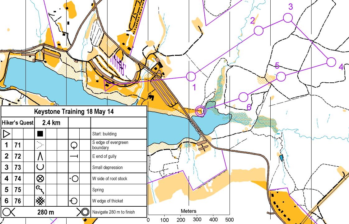
Hiker's
Quest
(2014, 2023, 2024)
Objective: To
practice finding a good attack point dynamically when some obvious
choices
have unexpectedly bad vegetation problems. To practice
dealing with
a map whose vegetation is out of date.
Given
a map that
contains only trails,
roads, open spaces, streams, buildings and north lines, find your way
around
a course. Controls are on standard features and the control
descriptions
specify what to look for; however, none of the control features are
shown
on the map and none are on trails. The idea is to find a good
attack
point using the little information that you have with one
hint. Hint:
It is possible to reach each control without going through dense
vegetation;
although you may need to deal with a little light green or slow undergrowth
in a few places.
Here is an example map: Hiker's
Quest
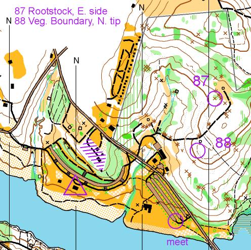
Course Setters Test (2014) Objective: To practice finding control locations with no marker and placing controls correctly, according to the control description.
This
is done with a
partner. Choose
as your partner someone who has similar orienteering ability and
speed.
Each partner is given 2 or more control flags, a map showing where
these
are to be placed and control descriptions. The maps are
different.
Both partners are started at the same time; their task is to place the
control flags properly (in the center of the circle as the description
states) and return to a designated location (shown on both
maps)
as soon as possible. At the meeting place, they exchange maps
and
go pick up the control flags placed by their partner. Then,
both
return to the start. When both have returned to the start,
they critique
the placement of the controls by their partner.
Here is a sample map: Course
Setter
Short-term Memory-O (2015, 2017, 2019)
Objective: To practice navigating without constantly looking at the map.
At the start, you will be allowed to study a map showing the start and the location of your first control; you may study this map until you are ready to start. You must navigate to this control without a map. You will be allowed to take with you only a set of control descriptions and a punch card. When you reach the first control, you will find a small piece of a map showing the location where you are and the location of the next control. You must navigate to this next control without a map. This process will continue until you have reached the last control where you will find a map showing the location of the finish which you must also navigate to without a map.
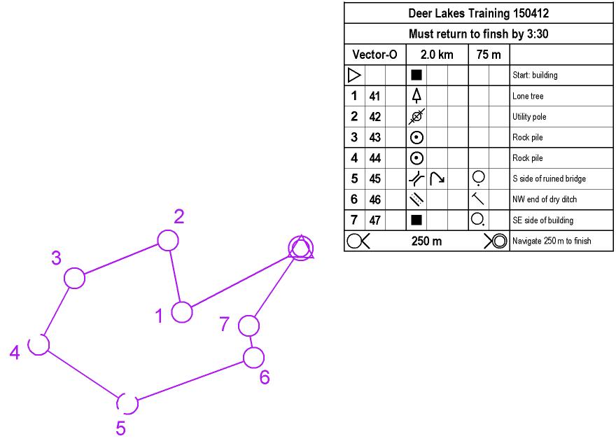
Objective: To practice remembering key terrain features that will help in navigating the course and to practice using bearings and distance measurement.
At the start, you will be allowed to study a regular orienteering map showing the entire course to be covered; you may study this map until you are ready to start. You must navigate this entire course with a map that contains only control circles and lines connecting them. The circles and lines will be drawn exactly as if they were on a normal orienteering map. You will also be given a set of control descriptions and a punch card. Here is an example: Vector-O
Partner Relocation
Objective: To practice relocation.
This is done with one partner. Each person is given a map but with alternating controls - partner A's map shows controls 1, 3, 5, etc.; partner B's map shows controls 2, 4, 6, etc. The partners are not allowed to look at each other's maps at any time. The two partners go together to all controls; A goes to the first control and B must follow along on his/her map. Then, B goes to the second control while A follows on his/her map. This alternating of navigation continues until both reach the finish. Each partner gets a punch card and must punch at all controls.
Total
Relocation
Objective: To
quickly find your
location on a map
This is done as a small group. Maps are marked with several control points; however, no control flag is placed at the control point. So, obvious (easy) control points should be chosen. Each person in the group gets a map but only one person (the leader) looks at the map. The leader takes the group along some indirect route toward but not all the way to the first control. The route should have a few twists and turns. When the leader stops, everyone else in the group looks at his/her map, determines their location and runs to the first control. Switch leaders after each control.
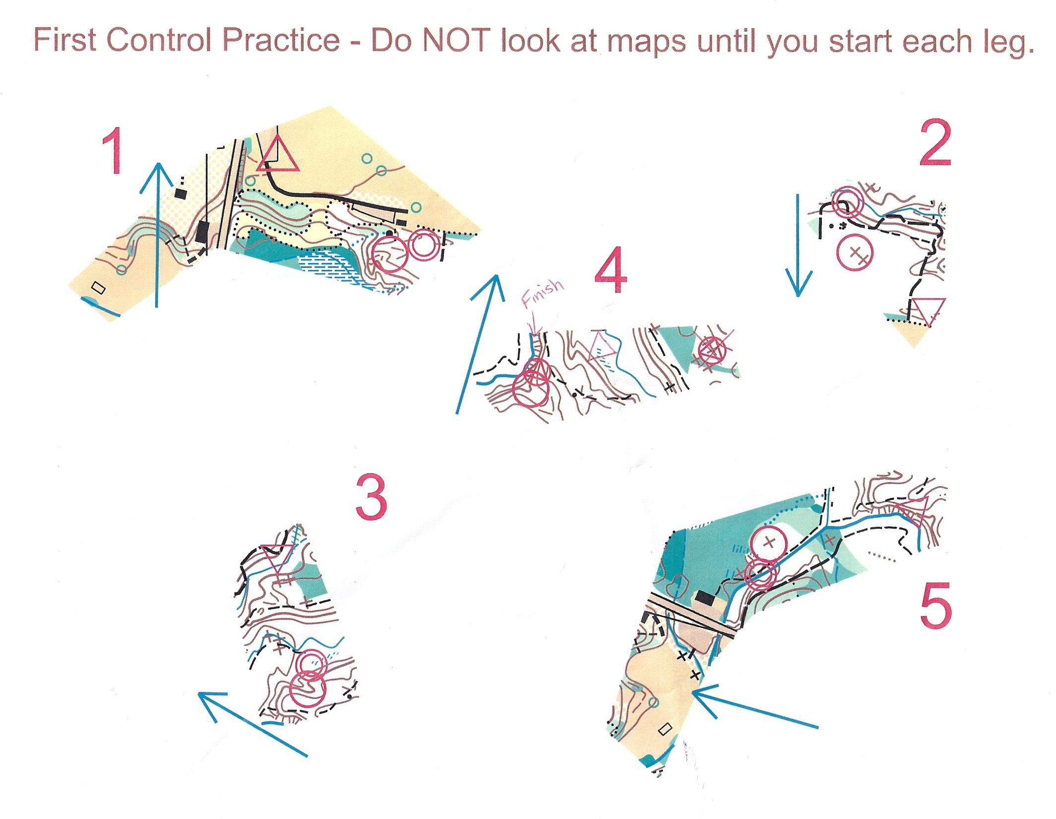
First
Control
Objective: To
develop a routine
to move quickly and accurately to the first control
A map has been prepared to show the start, one control and finish for 5 different map segments. The finish for the first segment is the start for the second segment; the finish for the second is the start for the third and so on. The control for each segment has a flag; the start and finish have only streamers. Two, three or four runners start at the same time; one of them says "go"; all then flip over their map, orient it and run to the control and punch. Map segments have been rotated on the page; but a blue north line for each segment shows the direction of magnetic north. Upon reaching the control, you should walk to the finish and turn the map face down; you should not look ahead at the next segment. Here is a sample group of map segments: First Control
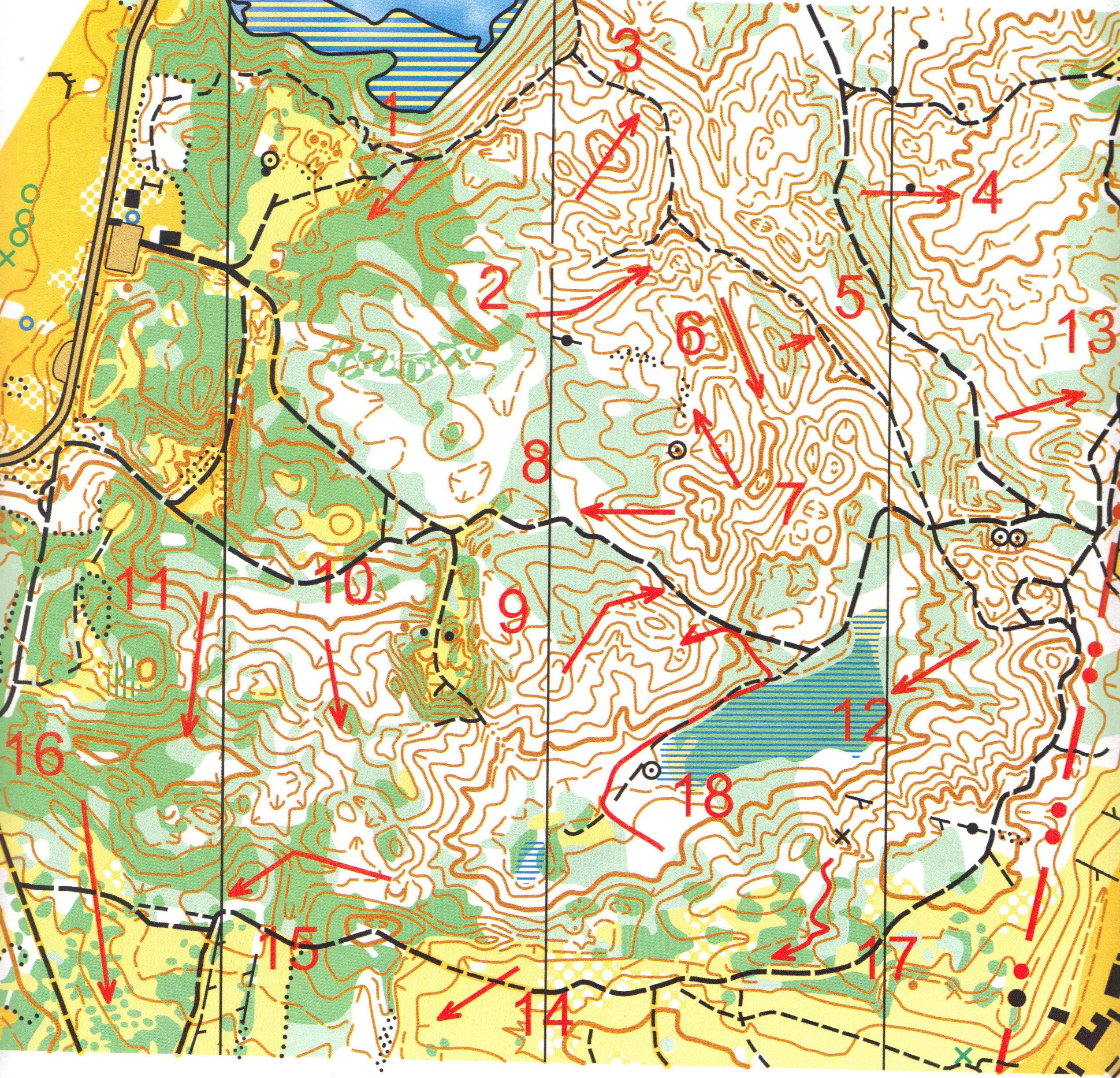
Determining
Up/Down (written exercise)
Objective: To
practice figuring
out which way is uphill and which way is downhill
A map has been prepared in which a series of arrows have been drawn. You are to determine if each arrow is going up or down or level or a combination thereof. Evaluate the entire length of each arrow. Write your answers on a separate paper and compare then to the answers which will be provided. Here is a sample map: Up and Down
Distance
Evaluation
Objective: To
estimate distance
traveled
Using the 100 m length that is marked off by orange flags, count how many paces you take while walking, running slow, and running fast. You should count each time your right foot hits the ground and start your walk/run on your left foot.
Do the same exercise
using a long shallow
reentrant or a gently sloping hillside on which there is a 100 m length
marked off. Again, count your paces while walking, running
slow and
running fast both uphill and downhill. Write down the numbers
for
future reference; these may be used in subsequent events (if you
remember
them) to help you judge distances traveled.