| Date | Location | Start Times | Courses | Cost |
| 30 Aug | Yellow Creek South, Woodland Pavilion | 11 am to 2 pm | Beginner; Novice; Intermediate; Advanced short and long | $6 per map* |
If you are planning to come to this event, please preregister at
http://www.wpoc.org/preregistration.php
Preregistration Deadline: 11:59 pm 27 Aug
Preregistration does not involve paying any money until you come to the event. Also, the cost is waived for preregistered kids; so they are free.
Anyone who is NOT preregistered (including kids) pays $1 more than the normal cost and is NOT guaranteed a preprinted map.
Each preregistered person/group is guaranteed one preprinted map. If a group wants multiple maps, it should preregister in pieces.
If you would like to find out more, go to our Web site www.wpoc.org
Or call Jim Wolfe at 814 255-6606 or e-mail jlwolfe@atlanticbb.net
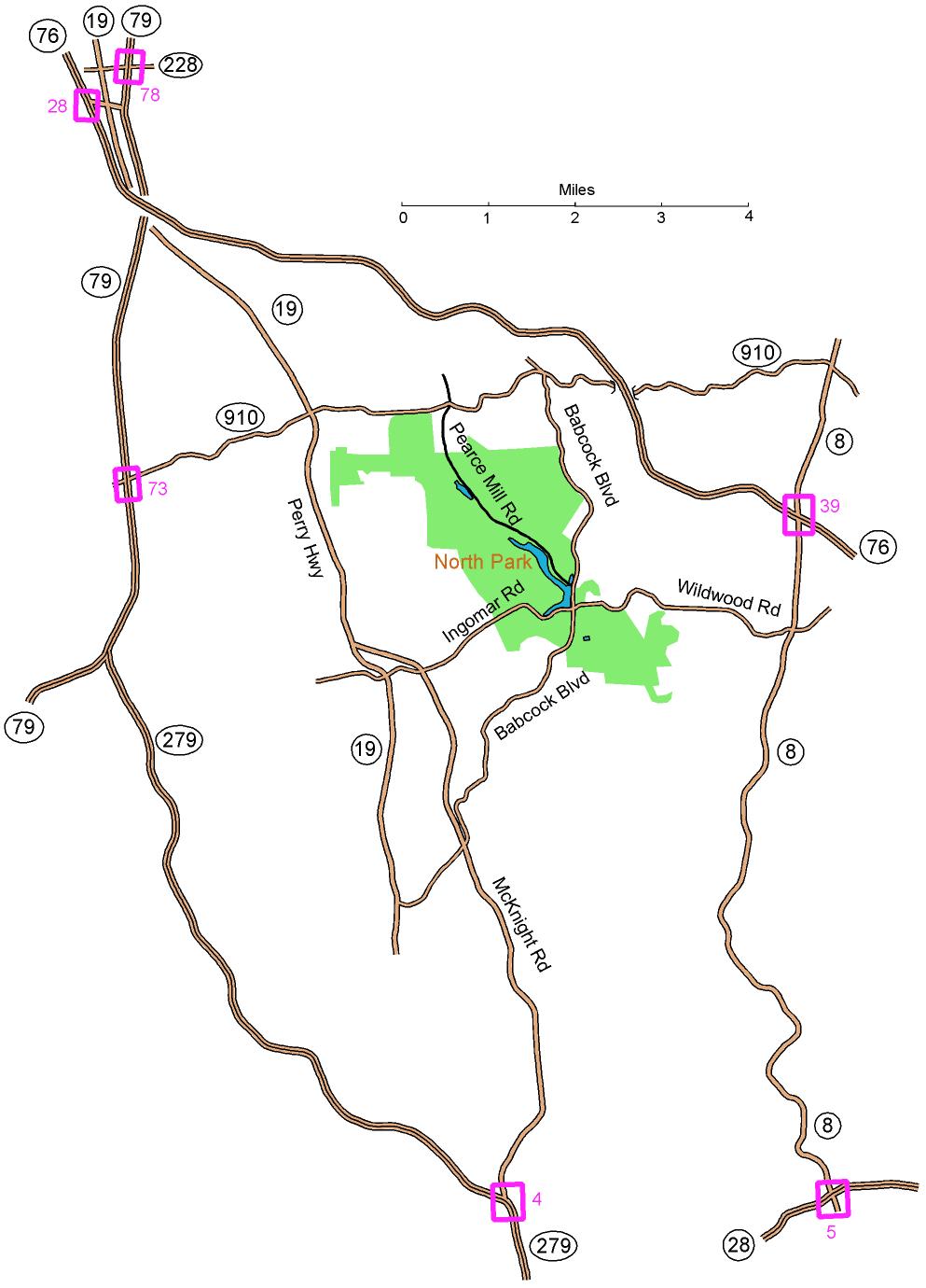
From the East: At turnpike (I-76) exit 39, take Route 8 south (1.3 miles).
Turn right onto Wildwood Rd. This will become Ingomar Rd; continue on it
for 2.9
miles to the light at Babcock Blvd. Turn right onto Babcock;
go for 0.2 miles and turn left onto Pearce Mill Rd and go for 2.0 miles. Watch for the Miller Shelter
and the WPOC banner on a hill on the right.
From the South (on I-279): Take
McKnight Road (exit 4) and follow McKnight Rd 6.4 miles north to
Ingomar Rd. Bear right at the exit and follow Ingomar Rd about
2.1 miles until it crosses Babcock Blvd. Turn left onto Babcock and follow the
directions in bold above.
From the South (on Route 28): Take
Route 8 north (exit 5) about 7.4 miles. Turn left onto Wildwood
Rd. This will become Ingomar Rd; continue on it for 2.9 miles to the light at Babcock Blvd.
Turn right onto Babcock and follow the directions in bold above.
From the Northwest: At
turnpike (I-76) exit 28 (or at I-79 exit 78 via Route 228 west), take
Route 19 South (7.7 miles) to Ingomar Rd. (Don’t follow
Truck Route 19.) Turn left and follow Ingomar Rd about 2.7 miles
until it crosses Babcock Blvd.
Turn left onto Babcock and
follow the directions in bold above.
Here is a Google maps link to the
Miller Shelter
The GPS coordinates are 40.617337 N, 80.022959 W