 Directions to Deer Lakes Park
| Date | Location | Start Times | Courses | Cost |
| 06 Jun | Deer Lakes, Anglers Shelter | 11 am to 2 pm Saturday event; 90-min score will be in two parts | Beginner; Novice; 90-min Score | $6 per map* |
If you are planning to come to this event, please preregister at
http://www.wpoc.org/preregistration.php
Preregistration Deadline: 11:59 pm 03 Jun
Preregistration does not involve paying any money until you come to the event. Also, the cost is waived for preregistered kids; so they are free.
Anyone who is NOT preregistered (including kids) pays $1 more than the normal cost and is NOT guaranteed a preprinted map.
Each preregistered person/group is guaranteed one preprinted map. If a group wants multiple maps, it should preregister in pieces.
If you would like to find out more, go to our Web site www.wpoc.org
Or call Jim Wolfe at 814 255-6606 or e-mail jlwolfe@atlanticbb.net
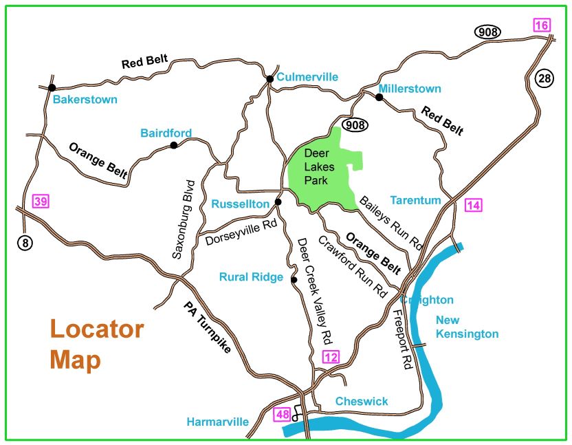
Directions to Deer Lakes Park
The map suggests that there are many ways to get there. Only two preferred routes are described below.
From PA Turnpike exit 48, go toward Cheswick & Springdale for about 0.5 miles (to the first traffic light). Turn left onto Pearl Street (this becomes Deer Creek Valley Rd). Follow this road for 5.7 miles going straight through at three stop signs.
The last stop sign is in north Russellton; take the next right after this stop sign (just past the First Commonwealth Bank). The road is labeled Orange Belt. Go about 150 meters under a railroad overpass and turn left into Deer Lakes Park. Follow the red and white orienteering signs in the park to the meet site.
From route 28, take exit 12 and turn right onto Hite Street. Follow Hite about 0.3 miles to the intersection with Deer Creek Valley Rd (also called Russellton Rd). Turn right at the stop sign and follow Deer Creek Valley Rd about 4.7 miles through two more stop signs. Then, continue as above.
From the east, at the intersection of Routes 22 and 66 in Delmont, take Route 66 North about 5 miles to Route 366. Turn left (west) on Route 366 and go about 8 miles until you reach a stop light as you enter New Kensington. This is the intersection of Route 366 and Route 56. Go straight through the intersection and onto TRK Route 56. Follow Route 56 1.3 miles to the second stop light; there, turn left and cross the bridge over the Allegheny River. On the other side of the bridge, turn right onto Freeport Rd. Follow that 1.3 miles to the second stop light and turn left onto Crawford Run Rd. After 2.1 miles on Crawford Run Rd, bear right onto Airport Rd. Follow Airport Rd 0.9 miles to a stop sign at Baileys Run Rd. There, turn left and go 1 mile to the entrance to Deer Lakes Park. Turn right into the park and follow the orienteering signs to parking.
Here is a Google maps link to the Deer Lakes entrance
The GPS coordinates for the entrance are 40.617378 N, 79.830770 W